⚠ Priority Intercept — Do Not Redistribute
This report was flagged for immediate review by relay-31 intake on 2026-04-23. Contents have not been sanitized. If you are not the intended recipient of this intercept, close this session immediately.
Situation Summary
On 22 April 2026 at approximately 03:14 UTC, routine sub-orbital surveillance of the Tularosa Basin sector registered a sustained geospatial anomaly across a 4.7 km² area southeast of INSTALLATION NAME. The anomaly is consistent with high-intensity electromagnetic interference originating from surface-level infrastructure, specifically Arrays 4 through 7 on the DESIGNATED COMPOUND.
Five capture frames were recovered before the surveillance feed was interrupted. Three of the five frames exhibit significant data corruption, including full-spectrum color displacement, block-level pixel loss, and coordinate-layer desynchronization. The remaining two frames show visible discoloration of terrain in a pattern inconsistent with natural geological or atmospheric phenomena.
This is not the first recorded event. Similar interference was logged on DATE REDACTED and again on DATE REDACTED, though neither prior event produced recoverable imagery. The current event is the first to yield partial visual confirmation of the anomaly's footprint.
Affected Coordinates
Primary anomaly center:
32.8509° N, 106.1045° W
Anomaly perimeter (estimated):
NW: 32.8571° N, 106.1182° W
NE: 32.8563° N, 106.0911° W
SE: 32.8441° N, 106.0927° W
SW: 32.8448° N, 106.1174° W
Proximity:
~14.2 km ESE of Holloman AFB perimeter
~8.7 km NNW of COMPOUND ID outer fence line
Tularosa Basin, Otero County, New Mexico
Note on coordinate accuracy
Electromagnetic interference from the array output has introduced a ±0.003° drift in the surveillance platform's positioning layer. Coordinates shown are best-estimate after post-processing correction. True anomaly center may differ by up to 330 meters.
Captured Imagery — 5 Frames Recovered
⚠ Imagery integrity warning
Frames TB-4471 through TB-4474 exhibit corruption consistent with high-energy EM interference during capture. Black regions represent complete data loss. Discolored regions may represent actual terrain anomaly or may be capture artifacts. OTA cannot distinguish between these without ground-level verification, which has not been authorized.
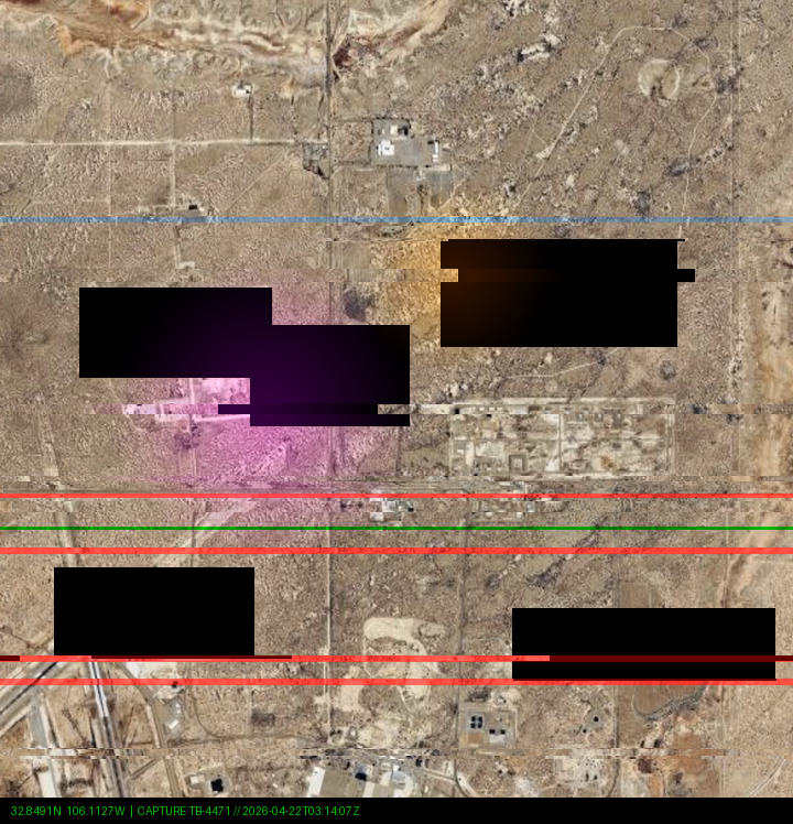
TB-4471 • 2026-04-22 03:14:07Z • Wide survey, initial pass
Heavily corrupted
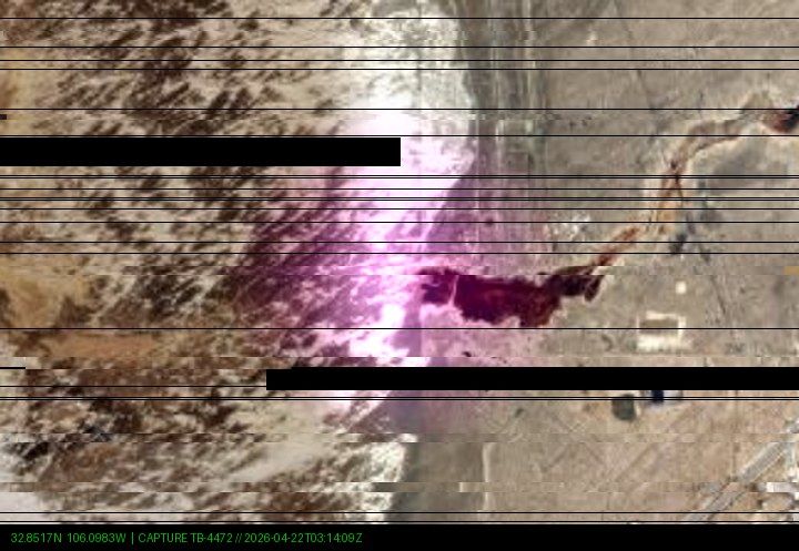
TB-4472 • 2026-04-22 03:14:09Z • Sector zoom, anomaly center
Partial / Redacted
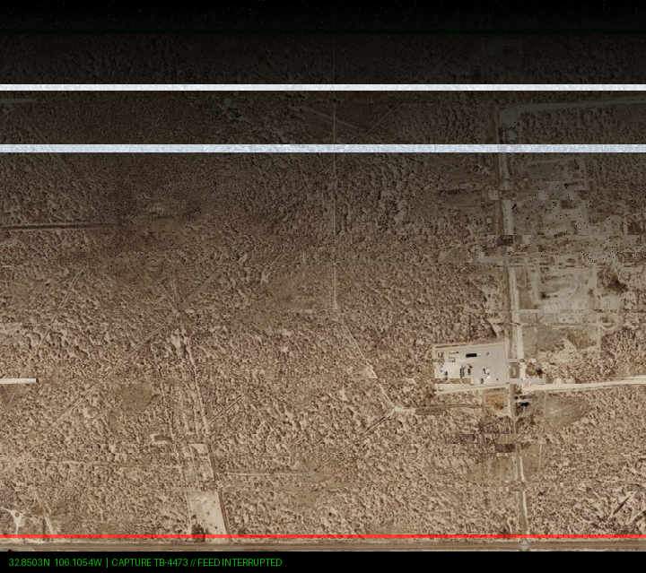
TB-4473 • 2026-04-22 03:14:12Z • Feed interruption during capture
Feed interrupted
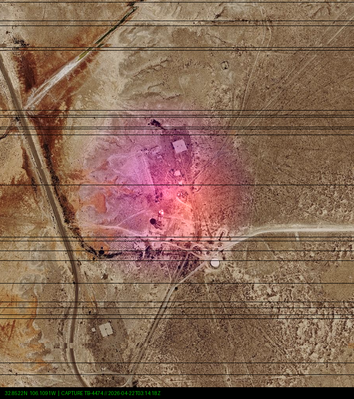
TB-4474 • 2026-04-22 03:14:18Z • Partial recovery, visible discoloration
Anomalous
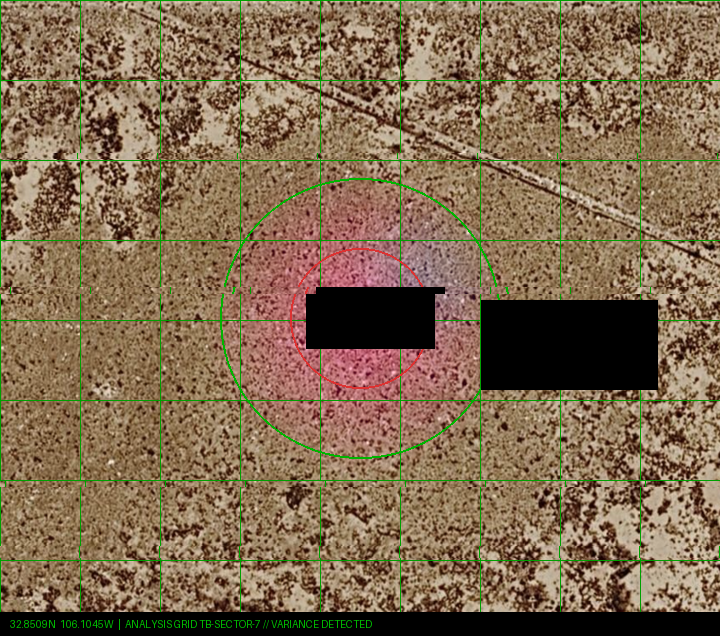
TB-SECTOR-7 • Post-capture analysis overlay • Variance mapping
Variance detected
Event Timeline
2026-04-22 • 02:58 UTC
Routine sub-orbital pass initiated over Tularosa Basin sector. No anomalies detected on pre-pass diagnostic.
2026-04-22 • 03:12 UTC
Platform positioning layer registers intermittent drift. Attributed to atmospheric conditions. Pass continues.
2026-04-22 • 03:14:07 UTC
First capture frame (TB-4471). Immediate data corruption detected across 62% of frame. Arrays 4–7 on REDACTED suspected as interference source.
2026-04-22 • 03:14:09–18 UTC
Four additional frames captured. Corruption severity varies. Frame TB-4473 shows near-total feed loss. Frame TB-4474 shows visible terrain discoloration in anomaly zone — purple-shifted spectral signature with no known natural cause.
2026-04-22 • 03:14:22 UTC
Surveillance feed terminated. Platform automatically aborted pass. Abort code: EMI-OVERRIDE-7F. This code is not documented in standard operating procedures.
2026-04-22 • 04:30 UTC
Automated incident report generated by LOAC-NA monitoring. Flagged for Subsector 12 review. No human acknowledgment logged for 11 hours.
2026-04-22 • 15:42 UTC
Incident report accessed by OPERATOR ID. Reclassified from ROUTINE to COMPARTMENTED within 8 minutes of access. No explanation logged.
2026-04-23 • 01:07 UTC
OTA relay-31 intercepts report during scheduled LOAC-NA archive sync. Flagged for priority intake.
OTA Assessment
The speed of reclassification — 8 minutes from first human access to COMPARTMENTED status — is not consistent with standard LOAC-NA incident handling. Routine geospatial anomalies are typically reviewed over a 72-hour cycle. The immediate escalation suggests the operator recognized the anomaly's significance, or was following a pre-existing protocol for events in this specific area.
Arrays 4 through 7 are referenced in other intercepted GCI documentation as components of the SYSTEM NAME, a subsurface infrastructure network whose purpose has not been fully determined by OTA. The Tularosa Basin coordinates were subsequently identified in the North American infrastructure survey obtained from the same LOAC-NA compliance archive — listed as anomalous entries CS-NORAM-034 and CS-NORAM-035, with corrupted designations and no acknowledgment in the compliance narrative. The site's presence in the filing appendix but absence from the body text is consistent with deliberate exclusion from the formal survey.
Ground-level verification has not been authorized. OTA does not currently have assets in the Tularosa Basin region. If you have access to the area or to related documentation, contact protocol is available via secure relay.
⚠ Do not attempt independent verification
The area surrounding the anomaly zone is within or adjacent to restricted military airspace and controlled-access land managed by the U.S. Department of Defense. Physical approach without authorization carries legal and personal risk. OTA does not encourage or endorse unauthorized access to restricted areas.